 The City Council examined transportation maps at a Monday workshop to determine how traffic patterns will change according to plans for the Columbia River Crossing Light Rail project*.
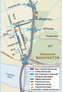
Council members saw visuals that show CRC access points at Fourth Plain, Mill Plain and the State Route-500/39th Street interchange.
The presentation was led by Vancouver Transportation Policy Director Thayer Rorabaugh, CRC Director Nancy Boyd, and CRC Environmental Manager Heather Gunderson.
The trio referenced the “locally preferred alternative” (LPA). It was reported that the Project Sponsors Council weighed in on determining these alternatives. Their evaluation generates the information needed to limit data collection and analysis to only pertinent information that is useful for policymakers to select the LPA, which is required by the Federal Transportation Administration. Preliminary design work has been done and a visual of the cross-section was shown Monday with light rail located on the lower deck of the southbound lanes.
The proposed bridge structure enters downtown over the top of Burlington Northern railroad tracks. The existing bridge comes in at ground level and passes underneath the tracks, so Rorabaugh said the CRC proposal would be far higher and could open the land currently consumed by freeway to be reclaimed as park land. This would also allow for an extension of Main Street to Columbia Way, which runs along the waterfront.
The biggest improvements to the Fourth Plain interchange will be in the area of the Central Park park-and-ride, where a lane will be added to the intersection as well as options for accessing and exiting high capacity transit without using the local street system. The CRC’s planned light right route enters the city on Washington Street and then reaches ground level at about Fifth Street with the first Light Rail Transit station planned between Fifth and Sixth streets. From there the transit system continues north on Washington, west on Seventh and north on Broadway with a station planned between Ninth and Evergreen. An additional station is slated between 15th and 16th.
Then the plan shows rail going north to 17th street and then east to the planned Central Park park-and-ride lot to be located on McLoughlin. Rorabaugh demonstrated the reverse route, tracing a parallel or side-running path. He said assistance from the Vancouver Working Group was instrumental in helping the city determine which kind of alignment to adopt. (The CRC website notes that the Vancouver Working Group consists of 22 members which met 12 times between January 2009 and July 2009 to advise on light rail design through downtown Vancouver to Clark College).
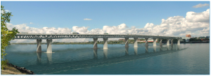
Boyd said a specific type of bridge is not described in the draft environmental impact statement. She said, “It identified an envelope, a spatial envelope that several bridge types could fit into.” The final environmental impact statement comes a little closer and describes a composite truss design.
After two review panels, the governors of Washington and Oregon chose the truss style design. (See April 2011 video of the governors’ announcement on couv.com).
The next step is to engage an architect to further the bridge design. “The public and design community will be involved in the process to come up with a design that reflects the character of community and the region,” Boyd said. She said this process will take much of the next year, and will probably start late fall. Once the design is fully developed, it will be submitted to the corps of engineers.
The workshop also showed access to Fourth Plain, which is slated to become an exit north of the State Route 500 & 39th Street interchange as a tunnel underneath the 39th Street on-ramp. Rorabaugh said another item still under discussion between the city and CRC staff is the environmental impact associated with retaining the current West bound SR-500 to Fourth Plain connection. The current design eliminates it.
“Living in the Minnehaha area, I’m pretty familiar with the area,” Councilman Bart Hansen said as he expressed gratitude for the upcoming St. John’s overpass (not part of the CRC project). Hansen then zeroed in on his concern for long-term plans that would benefit the Minnehaha area in the form of access from westbound State Route 500 to northbound I-5 and southbound I-5 to eastbound 500.
Heather Gunderson said that plan is actually included in the environmental impact statement as a phased option, but Nancy Boyd said the project doesn’t currently cover Hansen’s neighborhood. “It might be a good discussion for the future,” Boyd said. “If it becomes something that’s a priority.”
Rorabaugh confirmed it was in the project originally but was eliminated as a cost-saving measure. “It wasn’t absolutely important,” he said. “The project can still function without it.”
Councilman Jack Burkman seemed to pursue the Minnehaha elements to be put back into the plan by asking, “We can still keep working on that one?” To which Gunderson replied “Yup.”
* The well-documented cost to taxpayers, if the CRC stays on budget, is $10 billion. This was established by the Cortright Report (PDF) which used data from an independent review panel hired by the governors of Washington and Oregon. (View the panel’s final report.)
See our continuing coverage of the Columbia River Crossing Light Rail project.
Do you have information to share on the CRC? To respond anonymously call 260-816-1426. To allow your comments to be used on COUV.COM call 260-816-1429.


