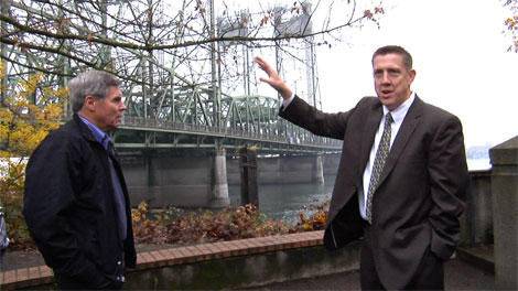
It’s one thing to see a drawing of the proposed $10 billion* Columbia River Crossing Light Rail project. It’s quite another to stand on the north end of the Interstate Bridge and imagine the massive concrete structure stretching across the Columbia River and touching down on Vancouver’s waterfront.
That was an opportunity given to members of the Washington State Transportation Commission (WSTC) on Nov. 15 during a three-hour briefing and bus tour of the Columbia River Crossing (CRC) project, which will include two replacement bridge spans, a light rail line, and major alterations to freeway interchanges from North Portland to Vancouver.
Project planners expect to fund construction with $1.25 million in federal funds, $900 million of state tax dollars split between Oregon and Washington, and about $1.3 billion in toll revenue.
The seven-member Transportation Commission sets toll rates on bridges, roadways, and ferries statewide, and advises the governor and Washington State legislature regarding transportation issues. The commissioners were in town to learn about major transportation issues facing Clark County.
“We feel it is a service to the state by trying to talk to different corners of the state and to try to compile and give the information that’s available to the legislature to help them make better choices,” said Phillip Parker, a retired electrician who represents Clark County on the commission.
Commissioners meet with Boyd
Prior to the bus tour, the commissioners met with CRC Director Nancy Boyd and traffic engineer Ryan LeProwse at Vancouver City Hall for a project update.
Boyd said the CRC’s primary goals are to reduce congestion, improve safety, and extend light rail across the river through downtown Vancouver to Clark College.
The north and south bridge spans will each have three “through” lanes and two additional “add/drop” lanes on the upper deck, with a second level for light rail, pedestrians, and bicycles.
“Predictability is important for commuters and it’s important for freight and it’s important as a business plan into the future, for them to be able to rely on the transportation,” said Boyd.
Boyd added that retrofitting the bridges to meet seismic standards was considered (a CRC panel in 2006 said it was perfectly feasible), but the idea was abandoned due to the lingering problem of bridge lifts.
Boyd said, “Is there still a span that could be usable with some investment in the existing structure? Yes. But given everything else that’s needed through the corridor, that was one of the options that was not considered after that early time frame.”
Most bottlenecks in Oregon
LeProwse, an engineer with CRC contractor David Evans and Associates, presented a variety of traffic-related statistics, including the number of collisions that occur within the project area (400 annually), as well as levels of congestion along I-5 between Ridgefield and the Marquam Bridge in Portland.
Using data from 2005, LeProwse described the interstate bridge as one of four main bottlenecks along I-5 for southbound traffic. The other three – Delta Park, the I-5/I-405 split, and the Rose Quarter – are all in Oregon.
For northbound traffic, graphs show approximately four hours of congestion (traffic moving 30 mph or less) from I-84 in Portland to the mouth of the northbound Interstate Bridge.
“It’s very rough,” said LeProwse. “Four hours of congestion can take you a while.”
LeProwse said that 35 percent of traffic crossing the river on I-5 enters and exits the freeway within two miles of the bridge. The majority of interstate freight uses I-205 to get around downtown Portland, so the freight that crosses the Interstate Bridge is primarily local.
Rather than add the number of through lanes, designers elected to tack on two additional add/drop lanes to allow drivers making short trips to avoid having to merge into the main flow of traffic entirely.
“These are to help that short interchange spacing,” said LeProwse. “We’re not able to remove any interchanges so the best way to help with merging, diverging, and weaving in this area is to add these [add/drop] lanes.”
Questions arise on outdated assumptions
The CRC staff expects population in Clark County to steadily grow by 46 percent and reach 665,000 in 2030. LeProwse said that under a “no-build” option, congestion around the Interstate Bridges would increase to 15 hours a day with 184,000 of daily traffic. With the CRC project as currently designed, congestion is expected to drop to 4.5 hours a day affecting 178,000 vehicles a day.
Noting that the CRC was basing its conclusions on six-year-old data, WSTC Executive Director Reema Griffith asked whether the CRC would adjust its assumptions given the lingering effects of the recession.
“Is there going to be any updates of that considering the economic changes that are going on?” she asked.
Boyd said they used Metro’s most current statistics, but she acknowledged that Oregon State Treasurer Ted Wheeler had determined last summer that the CRC was using outdated traffic predictions and should expect 15 to 25 percent less in annual gross toll revenue, as a result.
Boyd said Wheeler’s recommendations were incorporated in the financial section of the Final Environmental Impact Statement (FEIS), but not in the environmental chapters.
“We’ll definitely do a more detailed analysis as we get closer to construction and closer to the whole financial implementation of it,” Boyd said.
WSTC chairman Dick Ford mentioned that predictions regarding toll revenues for the Tacoma Narrows Bridge haven’t come to pass, either. Not knowing how long it will take the region to recover from the recession makes estimating traffic patterns – arguably the main justification for bridge construction – a challenge.
“That’s what the recession has done,” he said. “The big problem with all of this is if you assume the recession is going to stick around forever, then you’ve got a new set of problems, but if you say in due course we’ll return to mean, then you have another set of assumptions. That’s the problem we would face or whoever sets the tolls would face.”
WSTC commissioner Anne Haley, who represents Walla Walla County, asked whether the CRC had analyzed the amount of drivers that would avoid tolling on I-5 by taking I-205 instead, and whether tolling both bridges would be necessary. Boyd said their analysis showed that I-205 shouldn’t be tolled.
“There wasn’t enough diversion to warrant that,” Boyd said.
Griffith asked if the CRC had considered building a third bridge, and Boyd said yes, but that it ultimately wasn’t chosen. To investigate that in the future would require additional environmental study, she said.
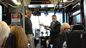
At the conclusion of the briefing, the WSTC commissioners joined CRC staff on the bus tour, which did a loop from downtown Vancouver to Clark College, Ft. Vancouver, Hayden Island, The Expo Center MAX station, and back again.
After the tour, commissioner Parker said he supported the CRC, but that the project’s future lies squarely in the hands of the Washington and Oregon legislatures.
“Until someone comes back how much the total bridge costs, how much each side puts in, everything else is just a guess,” he said.
* The well-documented cost to taxpayers, if the CRC stays on budget, is $10 billion. This was established by the Cortright Report (PDF) which used data from an independent review panel hired by the governors of Washington and Oregon. (View the panel’s final report.)
See our continuing coverage of the Columbia River Crossing Light Rail project.
Do you have information to share on the CRC? To respond anonymously call 260-816-1426. To allow your comments to be used on COUV.COM call 260-816-1429.


